File:Impact of Wikipedia layer in Google Maps.jpg
MyWikiBiz, Author Your Legacy — Friday May 17, 2024
Jump to navigationJump to search
Size of this preview: 800 × 309 pixels. Other resolutions: 320 × 124 pixels | 846 × 327 pixels.
Original file (846 × 327 pixels, file size: 66 KB, MIME type: image/jpeg)
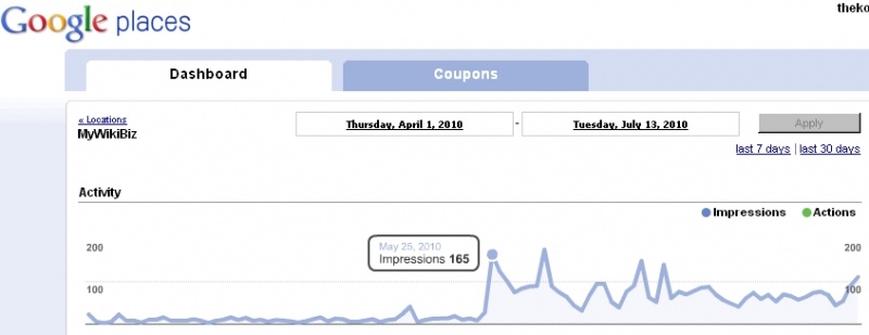
MyWikiBiz has had an article in Wikipedia since March 14, 2007. Geographic coordinates for the business were added to the Wikipedia article on November 6, 2009. However, it was not until May 24, 2010 that Google Maps' "Wikipedia layer" discovered and included the MyWikiBiz location in West Chester, PA.
This graphic represents the net result of that marriage between coordinate data in Wikipedia with the "Wikipedia layer" feature in Google Maps.
File history
Click on a date/time to view the file as it appeared at that time.
| Date/Time | Thumbnail | Dimensions | User | Comment | |
|---|---|---|---|---|---|
| current | 13:39, 21 July 2010 | 846 × 327 (66 KB) | MyWikiBiz (talk | contribs) | MyWikiBiz has had an article in Wikipedia since March 14, 2007. Geographic coordinates for the business were added to the Wikipedia article on November 6, 2009. However, it was not until May 24, 2010 that Google Maps' "Wikipedia layer" discovered and in |
You cannot overwrite this file.
File usage
There are no pages that use this file.